Wellbeing, Resilience, and Food-Desert-mapping. With Humanitarian OpenStreetMap Team, NHS Wales and Missing Maps/Medecins Sans Frontieres. PRESENTATION
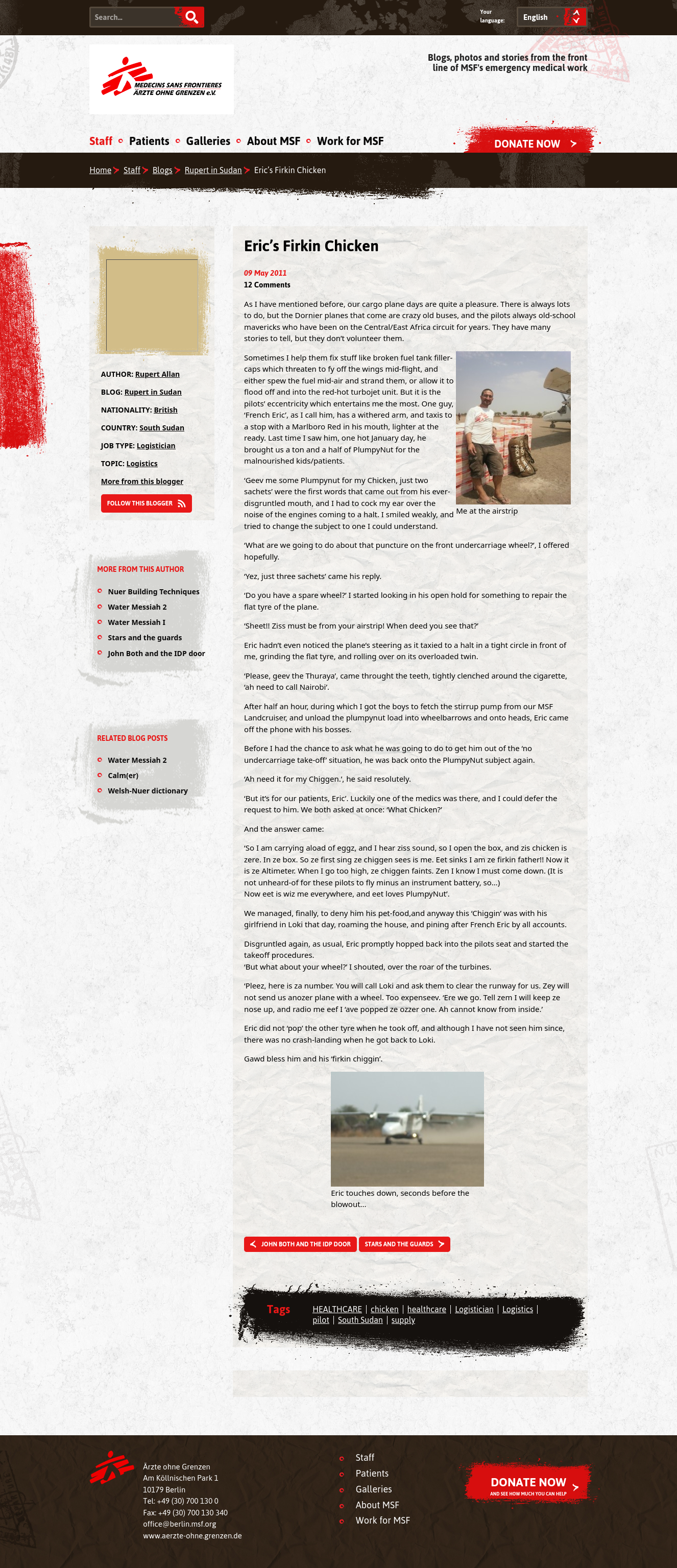
Community-led data helped to map wider determinants of Wellbeing, Co-morbidities, Social Exclusion and outbreak vulnerability. Reconnecting the NHS with its communities in the birth-place of the NHS (and of the Labour Party).
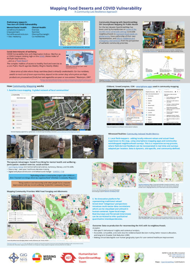
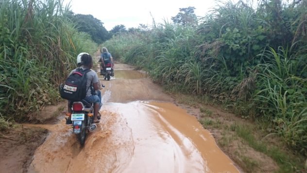
We adapted Motorcycle Mapping methods previously used with Medecins Sans Frontieres, Red Cross, UN, African Health Ministries and INGOs to use for mapping social inclusion, outbreak resilience, climate justice and lived Wellbeing experiences. Based out of Twyn Community Hub, Mel, Michael and Amanda were our community Disaster Risk Reduction mappers. Walking miles of Merthyr, they interviewed for perceptions of need, food and social access, and community assets. They then surveyed infrastructural provision realities site-by site. The reports created cultural, resource-access map layers, profiling a rich social capital, a proud pre-industrial heritage, (including ancient mythologies/holy sites), and the qualitative relations between perception and reality in the community voice. All available in the public domain, these anonymous data are your pocket, on all phone apps using OpenStreetMap/Mapbox etc wiki-maps.
To safeguard human lives quickly and effectively in humanitarian disasters, OpenStreetMapping (OSM) interventions generate life-saving maps whilst placing the governance and authorship of the field data into the hands of the communities where it originated.
Institutional data often do not exist in resource poor settings, and even where they do, hyper-local ‘expertise’ of citizen-generated data has an argued advantage of ‘trustworthiness’ over this more formal top-down information. (Muttaqien,Ostermann, Lemmens: 2018)
Although OSM may hold the dynamic potential to radically connect the physical with the digital, linking ‘situated knowledge’ in communities (the ‘specific’) with humanitarian overviews (the ‘universal’), this does not justify the indiscriminate mapping of ‘every corner of Africa’ simply for its own sake.
Exaggerated trust in new technology, too, can sometimes turn out to be dangerously ‘techno-colonial’, and actually detrimental to the safeguarding of human life. Where useful interventional maps depend on well-chosen words, often simpler and more lo-fi solutions have a more measurable impact.
Digitally-enabled mobile infrastructures can now prove highly resilient, refuting traditional assumptions linking mobility with ‘disadvantage’. Across cultures, demonstrations of chosen itinerance are beginning to query ‘digital realism’, imposing plural ontologies of ‘place’, re-visiting traditions of ‘language-code’ in which technology manifests as ‘taxonomy’. In this, ideas of ‘locale’ emerge more as process than place.
This chapter draws upon experiences of refugee-mapping using ‘local knowledge, local people, and local tech’, and on attempts to convey data in a way that universally translates. It will use field-derived perspectives to debate the multiple narratives which OSM mapping (and OpenDataKit tooling) enables.
To see how this technology adapts to ground-breaking community-mapping of COVID Vulnerability and Food Deserts in deprived areas of the UK, follow THIS LINK.
Who knew that a book about personal data ethics, track and trace, government handling of life-saving disaster mapping data would become so topical?
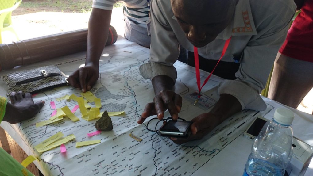
Deo coaching new OSM members taken from surrounding neighbourhoods
My contribution is the final chapter, ‘Modalities of United Statelessness’: about bottom-up, ‘hyper-local’, community-owned motorcycle-mapping data in Uganda’s ongoing refugee crisis. Local Ugandans and international refugees together ‘wiki-mapped’ disease outbreak and social protection data, in the Congolese/South Sudanese refugee settlement areas.
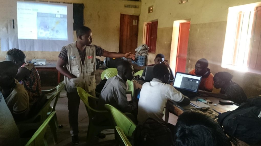
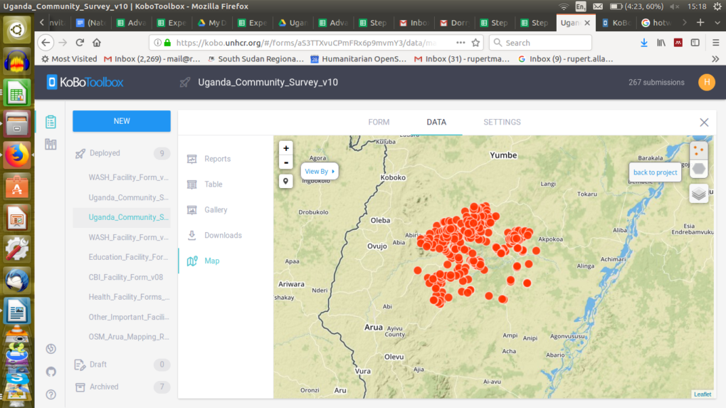
As members of the Ugandan Humanitarian OpenStreetMap Team, they adopted OpenStreetMap usernames. Then, using their own android phones, created a trailblazing resource of life-saving health, food, and water map data, now broadly used by UN, NGO, and Government emergency and development coordinators.
Humanitarians being part of ‘the solution’, rather than part of ‘the problem’.
Live Map Data (Credit: Kobo Toolbox/Kobo Collect)
I argue this valuable ‘Data Preparedness’ to be a solution to many pandemic issues, and this view seems borne out by Uganda’s excellent COVID-19 record to date.
…. I’d love if it got way beyond just academic community, as scholarship on the politics of representation and contemporary humanitarian ethics is scant, but really really important.
I liked this bit of the blurb, finding it particularly topical for the current times:
‘….Some have argued that representation has diminished in humanitarian crises as people are increasingly reduced to data points. In turn, this data has become ever more difficult to analyse without vast computing power, leading to a dependency on the old colonial powers to refine the data collected from people in crisis, before selling it back to them.’
Book also available through Open Access.
Here is a link to some twitter feeds about the event…
I gave a talk about West Africa Motorcycle Mapping (WAMM2017), and our activities in Sierra Leone, building a map and creating postcodes by which to deliver and direct medical and humanitarian relief in a resource-poor post-Ebola crisis environment.
‘Local People, Local Technology, Just Add Knowledge’